Explore Brazil's Geography with GeoAtlas - Geografia do Brasil App!
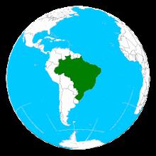
Learning about Brazilian geography just got easier! GeoAtlas - Geografia do Brasil is a fantastic new app designed to help teachers and students alike delve into the rich geographical details of Brazil's regions and states.
This user-friendly app offers a wealth of information, including detailed descriptions of each region, climate data, economic insights, demographic information, terrain analysis, vegetation details, and hydrographic features. Visual learning is key, and GeoAtlas provides interactive map visualizations for easy navigation.
Key Features of GeoAtlas:
Here are six compelling reasons to download GeoAtlas:
❤️ Comprehensive Regional Overviews: Gain a deep understanding of Brazil's diverse regions and their unique characteristics.
❤️ In-depth Regional Data: Explore climate patterns, economic drivers, population statistics, topography, plant life, and waterways for each region.
❤️ State-Specific Information: Discover essential facts, historical context, and key data for every Brazilian state.
❤️ Interactive Map Navigation: Easily explore Brazil's geography with the app's intuitive and interactive map.
❤️ Engaging User Interface: GeoAtlas makes learning fun and accessible with its clean and easy-to-use design.
❤️ Stay Updated on Facebook: Connect with the GeoAtlas community on Facebook for the latest news, updates, and extra resources: https://www.facebook.com/geoAtlasBr/
Ready to Explore?
Download GeoAtlas - Geografia do Brasil today and embark on an enriching journey through the diverse landscapes of Brazil!

