Aviation Weather with Decoder: Your All-in-One Aviation Weather Solution
This indispensable app delivers precise and current meteorological data, streamlining your flight planning. Access multiple weather reports concurrently for comprehensive situational awareness. Analyze historical weather patterns to enhance your understanding of weather trends. The app conveniently archives reports and NOTAMs, keeping all critical information readily available.
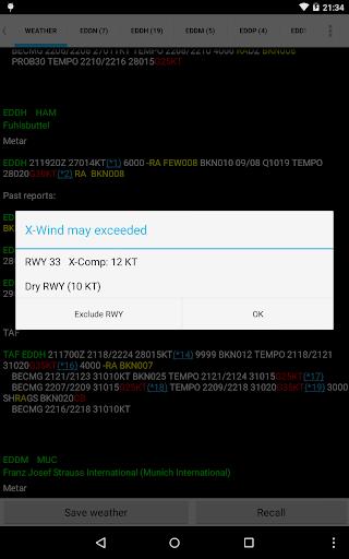
Easily locate airports using ICAO/IATA codes or airport names, and visualize them seamlessly on Google Maps. Personalize your experience by adjusting text color, size, and font. Helpful tools such as a METAR decoder, VOLMET access, and a crosswind calculator are included for enhanced convenience. Stay informed and optimize your flight operations with Aviation Weather with Decoder!
Key Features:
Multi-Report Access: Simultaneously monitor weather conditions at various locations.
Historical Weather Data: Review past weather reports to identify patterns and trends.
Report & NOTAM Storage: Save and easily retrieve vital weather information and NOTAMs.
Intuitive Input: Quickly find weather reports using ICAO/IATA codes or airport names.
Google Maps Integration: View airport locations directly on Google Maps for easy visualization.
Customizable Interface: Adjust text color, size, and font for optimal readability.
Summary:
Aviation Weather with Decoder offers a comprehensive suite of tools for accessing and interpreting METAR and TAF reports from NOAA. Its ability to display multiple reports, access historical data, store crucial information, and offer a personalized interface makes it efficient and user-friendly. The Google Maps integration and inclusion of built-in decoders and calculators add significant value for pilots and aviation professionals. Download today and make confident, data-driven decisions.